The Jerusalem Archeological Park, also known as the Davidson Center, displays excavated remains from the Second Temple period at the southern foot of the Temple Mount. Visitors walk through ancient streets, ritual baths, and architectural fragments while learning about Jerusalem's history through multimedia exhibits and archaeological findings from multiple historical periods.
The Jerusalem Archeological Park, also known as the Davidson Center, offers visitors the extraordinary opportunity to walk through excavated remains from the Second Temple period. Located just south of the Temple Mount, this remarkable archaeological site reveals the grandeur of ancient Jerusalem and provides tangible connections to 2,000 years of history. The park displays the remnants of Herodian architecture, ancient streets, and religious installations that once served millions of pilgrims who journeyed to the Temple.
Location
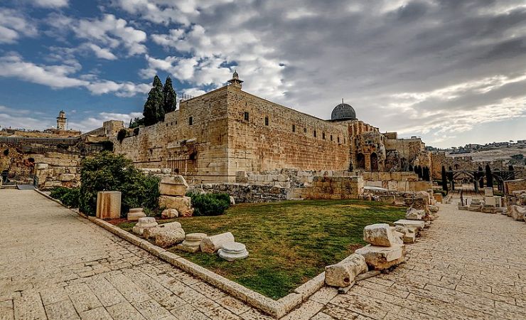
The Jerusalem Archeological Park, also known as the Davidson Center, sits within Jerusalem’s Old City, specifically on the southern and southwestern sides of the Temple Mount. Visitors can reach the site through the Dung Gate, which provides the most direct access from the Jewish Quarter. The park’s entrance lies approximately 100 meters from the Dung Gate, making it easily accessible for tourists exploring the Western Wall and other significant sites in this historic area.



Delving Deeper into the Jerusalem Archeological Park Findings
The Jerusalem Archeological Park displays remarkable archaeological findings from the Second Temple period, each telling the story of ancient Jewish life and practices. Visitors can walk among genuine Herodian structures that witnessed the final days of the Temple and the dramatic events of 70 CE.
The Huldah Gates
The Huldah Gates, known in Hebrew as “Sha’arei Hulda,” served as primary entrances to the Jerusalem Temple during the Second Temple period. Archaeological excavations have revealed remains of two gates from the Herodian renovation: the Triple Gate and the Double Gate. Both gates were constructed as part of Herod’s Temple Mount expansion and provided access via underground vaulted ramps that led pilgrims upward to the Temple platform.
The name “Huldah” has two potential origins rooted in traditions. In Hebrew, “Huldah” means “mole” or “mouse,” possibly referring to the tunnel-like nature of the gates where pilgrims ascended through dark passages before emerging into sunlight at the Temple Mount. Alternatively, the name might honor the First Temple prophetess Huldah, whom some traditions place in this area.
The Herodian Street and the Massive Fallen Stones
The Herodian Street, discovered adjacent to the Western Wall, served as the main thoroughfare of ancient Jerusalem during the Second Temple period. Archaeologists have uncovered 70 meters of this street, which measures 10-12 meters wide and features large, carefully trimmed and fitted stones designed for comfortable walking.
Dating evidence from the site includes three oil lamps typical of the first century CE and 17 coins struck by the Roman procurator of Judea in 17/18 CE, indicating the street’s completion occurred many years after King Herod’s death in 4 BCE. This archaeological evidence demonstrates the lengthy construction timeline of Herod’s ambitious Temple Mount project.
The most sobering sight along this street consists of massive stones hurled from the Temple Mount during the Roman destruction in 70 CE. These stones, some weighing several tons, have remained in their fallen positions for nearly 2,000 years, providing physical evidence of the catastrophic events described by the historian Josephus Flavius in his accounts of the Temple’s destruction.
The Monumental Staircase Leading to the Temple
The Southern Steps leading to the Temple Mount feature an unusual architectural design with steps of varying widths and heights. This intentional construction forced pilgrims to approach the Temple slowly and deliberately, preventing rushing and encouraging reflection. The design created a natural rhythm that enhanced the spiritual preparation required before entering the sacred space. Archaeological evidence suggests these steps could accommodate thousands of pilgrims during major Jewish festivals when Jerusalem’s population swelled dramatically.
The Corner Stone with the Trumpeting Inscription
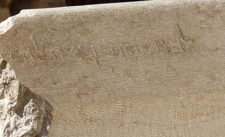
During the 1970s excavations, archaeologists discovered a large corner stone with typical Herodian construction characteristics at the southwestern corner of the Temple Mount. This stone bears a partially preserved Hebrew inscription reading: “To the trumpeting place to…” (לבית התקיעה לה…). The most probable completion of this inscription is either “proclaim” or “separate” (להכריז או להבדיל in Hebrew).
This stone originally marked the spot where Temple priests announced the beginning and end of the Sabbath through trumpet calls. The priest would sound six blasts at set intervals before Sabbath, providing a countdown that synchronized Sabbath observance throughout Jerusalem and ensuring all activities ceased appropriately.
Ritual Immersion Baths (Mikves)
The Jerusalem Archeological Park contains multiple ritual immersion baths or mikves that served the thousands of pilgrims who visited the Temple. These carefully constructed pools demonstrate the importance of ritual purity during the Second Temple period, as immersion in a mikve was mandatory before entering the Temple Mount. The mikves follow strict halakhic requirements regarding water source, pool dimensions, and construction materials, reflecting the sophisticated understanding of Jewish law during this period.
A Focus on the Corner of the Temple Inscription
During the 1970s excavations along the southwestern corner of the Temple Mount, archaeologists discovered a large corner stone displaying typical Herodian construction techniques. This limestone block, measuring approximately one meter in length, bears a partially preserved Hebrew inscription that has become one of the most significant archaeological finds related to Second Temple period rituals.
The inscription reads: “To the trumpeting place to…” (לבית התקיעה לה…). Archaeological consensus suggests the missing portion likely concluded with either “proclaim” or “separate” (להכריז או להבדיל in Hebrew), reflecting the dual function of the trumpet calls in marking sacred time.
This inscription provides direct physical evidence for the trumpet rituals described in ancient sources. Temple priests used this elevated position to blow a trumpet six times at set intervals before Sabbath, offering Jerusalem’s residents and pilgrims a systematic countdown until the holy day began. This ritual synchronized Sabbath observance across the city, ensuring all commercial and work activities ceased appropriately and the day of rest was observed universally.
Historical Sources and Significance
The discovery of this trumpeting inscription at the Jerusalem Archeological Park corroborates historical accounts found in rabbinical literature and the writings of the first-century historian Josephus Flavius. These sources document the systematic use of trumpet calls to mark religious observances from the Temple Mount’s highest points.
The Mishnah (Sukkah 5:5) describes this practice: “And on Shabbat eve they would add six blasts sounded adjacent to the onset of Shabbat: Three to stop the people from their labor, as the blasts inform the people that Shabbat is approaching and they stop working, and three at the onset of Shabbat to demarcate between sacred and profane.”
Josephus Flavius provides additional detail in his “Wars of the Jews” (4.9.12): “And having the advantage of situation, they further erected four very large towers… where one of the priests usually stood and gave a signal beforehand in the evening with a trumpet at the beginning of every seventh day, as also in the evening when the sabbath day was finished, giving notice to the people when they were to leave off work, and when they were to go to work again.”
The discovery location and inscription content demonstrate the careful organization and central importance of religious rituals during the Second Temple period. The trumpet’s sound from this prominent southwestern corner would have carried throughout the Jerusalem city and surrounding areas, reaching both permanent residents and the thousands of pilgrims who filled Jerusalem during major festivals.
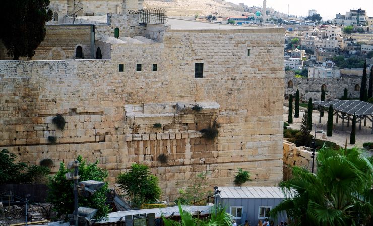
Robinson’s Arch: The Monumental Staircase
Robinson’s Arch represents one of the most impressive archaeological features at the Jerusalem Archeological Park. This monumental stone arch supported a massive staircase that provided direct access from the Tyropoeon Valley to the Temple Mount during the Second Temple period. The arch derives its name from American biblical scholar Edward Robinson, who first identified its remnants in 1838 during his groundbreaking archaeological survey of Palestine.
The arch originally stood at the southwestern corner of the Temple Mount, creating a crucial connection between the busy commercial district below and the sacred precincts above. This positioning made it one of the primary entrances to the Temple complex, accommodating the thousands of pilgrims who visited Jerusalem during major Jewish festivals.
Historical Construction and Purpose
Robinson’s Arch formed part of King Herod’s massive renovation and expansion project of the Second Temple, which began around 20-19 BCE and continued for decades after his death. The structure was engineered to connect the Tyropoeon Valley street, a major commercial thoroughfare lined with shops and markets, directly with the Royal Stoa at the southern end of the Temple Mount platform.
This connection proved vital for both religious and economic reasons. The Tyropoeon Valley street served as the location of the city’s Lower Market, where pilgrims could purchase animals for sacrifice and exchange currency. The Royal Stoa above functioned as a grand basilica complex that housed both commercial activities and legal proceedings, including meetings of the Sanhedrin, the Jewish high court.
The architectural design ensured smooth flow of pedestrian traffic between these different levels of activity, allowing pilgrims to conduct necessary business transactions before ascending to participate in Temple rituals.
Engineering and Archaeological Evidence
Modern archaeological excavations have revealed that Robinson’s Arch, contrary to earlier theories suggesting it supported a bridge, actually carried a monumental flight of steps. The arch worked in conjunction with a series of smaller supporting vaults to create a stable foundation for this massive staircase system.
The engineering specifications were impressive: the main arch measured approximately 15.2 meters in width and carried an estimated weight of 1,600 tons. The entire structure rose about 17 meters above street level, constructed from local limestone using the distinctive Herodian masonry techniques characterized by precisely cut stones with marginal drafting.
Archaeological evidence includes pottery sherds, coins, and architectural fragments that help date the structure’s use and eventual destruction. The most significant dating evidence comes from coins found in sealed archaeological contexts that confirm the arch’s construction timeline and active use period.
Destruction and Modern Discovery
Robinson’s Arch suffered destruction in 70 CE during the First Jewish-Roman War, only decades after its completion. The Roman siege and subsequent burning of the Temple resulted in the collapse of this magnificent structure, along with much of the Temple complex itself.
Edward Robinson’s identification of the arch remains in 1838 marked a watershed moment in biblical archaeology. His careful documentation and analysis provided the first scientific approach to understanding the Temple Mount’s ancient architecture. Robinson’s work demonstrated that physical remains could corroborate and illuminate historical accounts found in ancient sources like texts and the writings of Josephus Flavius.
The visible remains at the Jerusalem Archeological Park include substantial portions of the arch’s spring stones still attached to the Temple Mount’s western wall, foundation stones from the supporting structure, and scattered architectural elements that fell during the destruction. These ruins provide visitors with a tangible connection to the grandeur of Herodian Jerusalem and the catastrophic events that ended the Second Temple period.
Practical Information
The Jerusalem Archeological Park operates Sunday through Thursday from 8:00 AM to 5:00 PM (until 4:00 PM in winter months), Friday from 8:00 AM to 2:00 PM, and remains closed on Saturdays and Jewish holidays.
Limited parking is available near the Dung Gate, though visitors are encouraged to use public transportation or taxi services due to restricted vehicle access within the Old City. The site features wheelchair-accessible pathways for most major viewing areas, though some elevated sections may present challenges for visitors with mobility limitations.
Additional Information
What is the Davidson Center at the Jerusalem Archeological Park?
The Davidson Center serves as the modern visitor center and museum for the Jerusalem Archeological Park. It houses multimedia presentations, archaeological artifacts, and interactive exhibits that provide historical context for the outdoor archaeological site. The center includes air conditioning and restroom facilities.
How long does it take to visit the Jerusalem Archeological Park?
A typical visit to the Jerusalem Archeological Park takes approximately 1.5 to 2 hours. This allows sufficient time to explore the major archaeological features, read informational displays, and watch the multimedia presentations. Visitors who opt for guided tours or audio guides may spend up to 3 hours at the site.
Can I visit the Jerusalem Archeological Park and Western Wall on the same day?
Yes, the Jerusalem Archeological Park and Western Wall can easily be visited together, as they are located adjacent to each other. Many visitors combine these sites with other nearby attractions like the Western Wall Tunnels or the Jewish Quarter. The proximity allows for efficient sightseeing within the Old City.
Can I purchase tickets in advance for the Jerusalem Archeological Park?
Tickets can be purchased at the site entrance on the day of visit, and advance purchase is generally not required except for large groups. However, visitors planning to combine their visit with Western Wall Tunnel tours should book those separately in advance, as they have limited daily capacity and often sell out.
Resources and additional reading:
Nearby Sites
-
Dung Gate: One of the Old City’s gates. Provides access to the Western Wall and important sites of the Jewish Quarter such as the Broad Wall, The Western Wall Tunnels, the Roman Cardo, and the Hurva Synagogue.
-
Kidron Valley: The Kidron Valley runs between the Temple Mount and the Mount of Olives. Within the valley, you’ll find several ancient tombs, including the Tomb of Absalom, the Tomb of Zechariah, and the Tomb of Benei Hezir.
-
Pool of Siloam: An ancient freshwater reservoir. It is mentioned in both the Old and New Testaments.
-
Hezekiah’s Tunnel: An underground water channel that was carved beneath the City of David. Constructed to secure water for Jerusalem during the Assyrian siege.
Part of our Jerusalem Travel Guide →