Nimrod Fortress is a remarkably well-preserved medieval stronghold located on a narrow ridge at Mount Hermon's base in northern Israel. Built in the 13th century, it served as a strategic defensive position controlling the route from Damascus to Tyre. Despite never experiencing major battles, the fortress sustained significant damage from centuries of earthquakes yet remains impressively intact today.
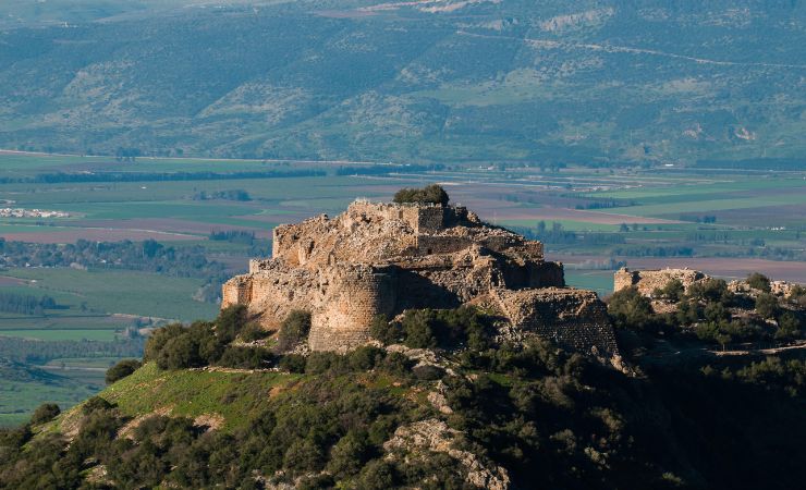
Nimrod Fortress is the most impressive medieval fortress in Israel, perched on a narrow basalt ridge at the foot of Mount Hermon roughly 800 meters above sea level. Built by Ayyubid rulers in the 13th century and later expanded by the Mamluks, the fortress stretches nearly 420 meters from end to end, making it one of the largest surviving medieval fortifications in the entire Levant.
Location
Nimrod Fortress stands in the Golan Heights, on a narrow ridge elevated about 800 meters above sea level, along the southern slopes of Mount Hermon. The Ayyubids, who built it, chose the site carefully to control a key access route from Baniyas to Damascus. The ridge runs east to west, and the fortress was engineered to take full advantage of the natural drop on three sides, with cliffs descending sharply toward the Hula Valley below.
Origin of the Name
The fortress has gone by several names over the centuries. Its original name, Qal’at al-Subeiba, appears in Arabic sources from the 13th century. The meaning of “al-Subeiba” is open to interpretation. Some believe it means “Leaping upon the Prey,” a fitting description when you see the fortress perched dramatically above the Hula Valley, almost like a leopard or lion ready to spring. Others suggest the name comes from the Arabic word ṣabīb, meaning “cliff” or “slope.”
The connection to Nimrod, the biblical king, warrior, and hunter, came much later. In the 19th century, Druze communities who settled in the area during the 1860 conflict began calling it Qal’at Namrud — Nimrod’s Castle. Nimrod, described in the Book of Genesis as a mighty hunter before the Lord, was a powerful ruler from the time before the Tower of Babel, and the Book of Jasher develops his legend further. The name stuck, and it is under Nimrod’s name that the fortress is known and officially designated today.
The History of the Nimrod Fortress
For many years, researchers believed that Nimrod Fortress had been established by the Crusaders in the late 12th century. The logic seemed straightforward: the Crusaders had fortified much of the Galilee and the Golan, and the scale of the construction pointed to a well-resourced military power. However, later studies revealed that the citadel’s foundations were actually laid by the Ayyubid rulers about a century later, around 1227 CE.
The impressive structure we see today was built under the leadership of al-‘Aziz ‘Othman, the ruler of Baniyas, likely funded by al-Malik al-Mu’azzam ‘Isa, ruler of Damascus. Their efforts were part of a larger Ayyubid strategy to defend against a possible attack by Holy Roman Emperor Frederick II. Following an alliance between Salah al-Din’s successor in Egypt, al-Kamil, and Frederick II, al-Mu’azzam and his brother al-‘Aziz ‘Othman launched a major fortification campaign in 1227 CE. Construction lasted about three years, creating a fortress that used the steep cliffs as natural defenses and established the massive, well-protected complex we see today. The fortress controlled the road leading from the Mediterranean coastal plain through Baniyas and up toward Damascus, making it a strategic chokepoint of the first order.
An inscription dating from 1228 CE, found at the site, marks the governance of al-‘Aziz ‘Othman. For a long time, historians attributed the fortress to the Crusaders, but in 1989, scholars Ronnie Ellenblum and Reuven Amitai reattributed it to the Ayyubids after analyzing historical sources and Arabic inscriptions found within the walls. Their findings reshaped how scholars understand the Ayyubid military building program in the southern Levant.
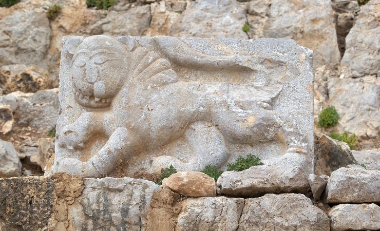
In 1260, the Mongols overthrew the Ayyubids and captured the fortress, along with the nearby city of Baniyas. However, their hold was short-lived. Just a few months later, Baybars, the Mamluk sultan, defeated the Mongols at the Battle of Ain Jalut and seized control of the region. Baybars reinforced and expanded the fortress, eventually granting it to his deputy, Bilik. Bilik carried out major building projects, commemorated by a remarkable Arabic inscription from 1275 CE still visible in the fortress today. Near this inscription, archaeologists found a stone relief of Baybars’ emblem: a lion playing with, or stepping on, a mouse — a symbol of strength found at other sites associated with Baybars, like the Lions’ Gate in Jerusalem and Baybars Bridge in Lod.
Under Mamluk rule, the fortress was expanded to include a palace and a mosque. After the final expulsion of the Crusaders from the Holy Land at the end of the 13th century, however, the citadel’s military importance declined. It continued to serve as a political stronghold and, by the 15th century, functioned as a palace-prison for rebellious nobles. The Mamluk historian Ibn Taghribirdi recorded that several emirs were exiled and imprisoned here during political purges in Cairo, suggesting the fortress retained real strategic value even in its diminished role. During the Ottoman period, the fortress gradually fell into disuse and was eventually abandoned, standing in ruins for centuries, occasionally offering shelter to shepherds and travelers. Mark Twain visited in 1867 and described it as “the noblest ruin of its kind in the world.” Systematic archaeological survey of the site began after the Six-Day War in 1967, led by Shmarya Gutman, and conservation work by the Israel Nature and Parks Authority has continued in subsequent decades.
What Can Be Seen at the Site Today
The Southwestern Tower: Serving today as the main entrance, this tower offers sweeping views across the Galilee, the Golan Heights, the Hula Valley, and the slopes of Mount Hermon. The panorama on a clear day extends as far south as the Sea of Galilee and north toward the snow-capped peak of Hermon itself. This tower was part of the original Ayyubid construction phase and was later reinforced under the Mamluks.
The Keep (Donjon): Located in the eastern part of the fortress, the keep was designed as a fortress within a fortress — a final stronghold in case of siege. Elevated above the rest of the site, it dominates the surrounding gates and defenses. Inside, remains of luxurious halls, water pools, and many rooms suggest it once served as the governor’s residence. The keep is separated from the rest of the complex by a moat hewn directly into the bedrock, once crossed by a wooden bridge. Near the moat’s southwestern corner is the oldest known inscription at the site, dating to 1228 CE during the rule of al-‘Aziz ‘Othman. The keep would have housed essential supplies like a cistern and oven to survive long sieges.
Baybars Inscription: A monumental Arabic inscription from 1275 CE, one of the largest surviving from the Mamluk period. It praises Sultan Baybars and his deputy Bilik, who led extensive building and restoration efforts at the fortress. The inscription likely adorned the second story facade and runs to several lines of carefully carved calligraphy, offering a rare window into Mamluk political culture and the way rulers celebrated their building achievements.
Baybars’ Lion Symbol: Close to the inscription is a carved relief of a lion, the personal emblem of Sultan Baybars. Similar carvings can be found at other Baybars-related sites like the Lions’ Gate in Jerusalem and Baybars Bridge in Lod. The Nimrod example shows the lion in the act of subduing a small mouse or rat, a composition understood as symbolizing absolute dominance over enemies.
The “Beautiful Tower”: This semi-circular tower projects from the fortress’s southern wall. Built by Baybars, its interior is octagonal (now appearing seven-sided due to partial collapse) and features a vaulted roof. The stonework and embrasures here are of particularly fine Mamluk craftsmanship. A small toilet cubicle, surprisingly well-preserved, is tucked into one corner, and the arrow slits are angled to provide overlapping fields of fire across the approach slope.
The Secret Passage: A hidden, stepped passage about 27 meters long, lined with high vaults. It runs from a northern gate tower to the outside, offering a concealed escape route in emergencies. The passage’s exit was cleverly hidden, reinforced with an arch to distribute the weight of the stones above. Earthquake damage is visible along the route, and several of the vault stones have shifted noticeably, giving a vivid sense of the seismic forces that shaped the ruin over the centuries.
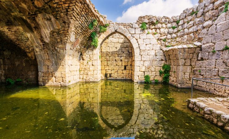
Water Cistern: A large, rock-hewn cistern collected rainwater through a network of channels (now mostly destroyed). At its peak capacity, the cistern could store enough water to sustain a garrison through an extended siege. Nearby, there may once have been a sabil — a public fountain common in Mamluk and Ottoman architecture — symbolizing the ruler’s generosity and providing drinking water to travelers and residents alike.
Additional Information
Medieval Period:
- Late 12th Century (after 1187): Following the Battle of Hattin (1187), Salah al-Din’s power rises, marking the beginning of the end for the Crusader Kingdom of Jerusalem.
- Early 13th Century:Salah al-Din’s empire is divided among his Ayyubid successors. Al-Kamil, ruler in Egypt, forms an alliance with Holy Roman Emperor Frederick II, agreeing to cede Jerusalem in exchange for Crusader help against his brother al-Mu’azzam ‘Isa, ruler of Damascus.
- Around 1227: In response to the alliance between al-Kamil and Frederick II, al-Mu’azzam ‘Isa (ruler of Damascus) and his brother al-‘Aziz ‘Uthman (ruler of Baniyas) begin extensive fortification work on Qal’at al-Subayba (Nimrod Fortress). This contradicts earlier theories of Crusader construction.
- 1227-1230: Fortification work continues for about three years, transforming the site into a massive and well-defended fortress.
- 1260: The Mongols conquer the region, including Baniyas and Qal’at al-Subayba, ending Ayyubid rule.
- Shortly after 1260: Mamluk forces under Baybars defeat the Mongols at the Battle of Ain Jalut, taking control of the region, including the fortress.
- Mamluk Period: Baybars expands and strengthens the fortress. He grants the fortress and Baniyas to his deputy, Bilik.
- 1275: An inscription commemorating Baybars’ construction work is placed at the fortress, mentioning Baybars, Bilik, and the builders. A stone with Baybars’ symbol, a young lion playing with a mouse, is found near the inscription. BaYbars elevates the status of the fortress and Baniyas to a governorship underyDamascus, directly appointed by the Sultan in Cairo.
- 15th Century onwards: The fortress serves as a palace-prison for nobles who rebelled against the central Mamluk authority.
Ottoman Period:
- 19th Century: The name “Nimrod” is first mentioned in Ottoman documents, referring to the fortress.
- 1867: Mark Twain visits the Holy Land and describes Nimrod Fortress as “the noblest ruin of its kind in the world.”
Modern Period:
- After 1967:Immediate survey of landscapes and sites in the Golan begins after the Six-Day War, led by Shmarya Gutman.
- Late 20th Century/Early 2000s: Archaeological research at Nimrod Fortress concludes it was primarily built by the Ayyubids in the 13th century, contradicting earlier theories.
Who actually built Nimrod Fortress?
Nimrod Fortress was built by the Ayyubid rulers, not the Crusaders as was long assumed. Construction began around 1227 CE under al-‘Aziz ‘Othman, ruler of Baniyas, with funding attributed to al-Malik al-Mu’azzam ‘Isa of Damascus. The Ayyubid attribution was established conclusively in 1989 by scholars Ronnie Ellenblum and Reuven Amitai based on inscriptions and historical sources found at the site.
Why was Nimrod Fortress built where it is?
The location was chosen to command the main road connecting Baniyas and the Mediterranean coastal plain to Damascus. The ridge sits about 800 meters above sea level, with sharp natural cliffs on three sides, giving defenders a decisive height advantage over any approaching force. Controlling this corridor was vital during a period of intense rivalry between Ayyubid factions and the looming threat of Holy Roman Emperor Frederick II.
Can you visit Nimrod Fortress and Banias on the same day?
Easily. The two sites are less than 5 kilometers apart along Route 99. Many visitors stop at Banias first to walk the waterfall trail and see the ancient temple precinct at Caesarea Philippi, then drive up the road to Nimrod Fortress in the afternoon. The Israel Nature and Parks Authority sells a combined ticket that covers entry to both sites, which offers a modest saving over paying separately.
Is there a connection between Nimrod Fortress and the biblical Nimrod?
The connection is entirely legendary rather than historical. The fortress was built in the 13th century CE, thousands of years after any period associated with the biblical Nimrod. The name was attached to the site in the 19th century by Druze communities who settled in the area, drawing on a folk tradition that linked ancient-looking structures across the Levant to the figure of Nimrod from Genesis. The original Arabic name, Qal’at al-Subeiba, predates the Nimrod association by several centuries.
Nearby Sites
- Banias Nature Reserve (Caesarea Philippi): Features the Banias Waterfall — the largest in Israel — along with ancient ruins and trails.
- Mount Hermon: Israel’s highest peak offers hiking trails in the summer and skiing in the winter.
- Tel Dan Nature Reserve: A beautiful combination of flowing rivers, dense greenery, and archaeological remains.
- The Druze Village of Majdal Shams: This vibrant village offers authentic Druze food, culture, and beautiful views over the Golan.
Part of our Galilee & Northern Israel Guide →