Tel Gezer is a major archaeological site in central Israel that preserves remains from the Canaanite, Israelite, and later periods. The tel features a massive six-chambered gate attributed to Solomon's reign, a high place with standing stones, and a water system. It provides evidence of ancient urban planning and fortifications spanning over 3,000 years of occupation.
Tel Gezer is one of Israel’s most significant archaeological sites in the ancient Near East, occupying a ridge in the Shephelah lowlands that ancient powers fought over for millennia. Its excavated layers reach back to the Chalcolithic period and carry forward through the Canaanite, Israelite, Hellenistic, and Roman eras, each stratum adding depth to a story that intersects Egyptian pharaohs, Israelite kings, and the everyday farmers who scratched their agricultural calendar onto a piece of limestone nearly three thousand years ago.
Where is Tel Gezer Located?
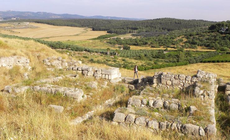
Tel Gezer sits in the Shephelah, the gentle hill country that runs between the coastal plain and the Judean highlands, roughly 30 kilometers southeast of Tel Aviv and about 8 kilometers north of Beit Shemesh. The site rises about 60 meters above the surrounding plain, giving it an unobstructed view across the valley below.
Biblical Context
Few Canaanite cities appear in the Hebrew Bible as consistently as Gezer. Its name surfaces across Joshua, Judges, Kings, and Chronicles, each mention anchoring the tel to a different chapter of Israelite history. The site appears in biblical scholarship as a touchstone for understanding how the Israelite monarchy consolidated power in the lowlands. The key passages are worth reading alongside the physical evidence visible on the ground today:
- Joshua 10:33: The first mention of Gezer in the Bible occurs when Joshua leads the Israelites in their conquest of Canaan. Horam, king of Gezer, comes to aid Lachish, but Joshua defeats him and his people, leaving no survivors: “Then Horam king of Gezer came up to help Lachish; and Joshua smote him and his people until he had left him none remaining.”
- Joshua 12:12: Gezer is listed among the thirty-one cities defeated by Joshua: “The king of Eglon, one; the king of Gezer, one.”
- Joshua 16:10: The Israelites did not drive out the Canaanites living in Gezer, and the Canaanites continued to live among the Ephraimites: “They did not dislodge the Canaanites living in Gezer; to this day the Canaanites live among the people of Ephraim but are required to do forced labor.”
- Judges 1:29: This verse reiterates that the Israelites did not drive out the Canaanites living in Gezer, highlighting the incomplete conquest of the land: “Neither did Ephraim drive out the Canaanites that dwelt in Gezer; but the Canaanites dwelt in Gezer among them.”
- 1 Kings 9:16-17: This passage describes how Pharaoh, king of Egypt, captured Gezer, burned it, killed the Canaanite inhabitants and then given it as a wedding gift to his daughter, Solomon’s wife. And Solomon rebuilt Gezer.” The destruction layer associated with this event has been identified in excavations, and the rebuilding phase aligns with the construction of the six-chambered gate that still stands on the tel today.
Tel Gezer's History
Tel Gezer carries more than five thousand years of continuous human activity within its 12-hectare mound. The earliest settlers, during the Chalcolithic period toward the end of the fourth millennium BCE, carved large caves from the bedrock and used them as dwellings. By the Early Bronze Age, around 3000 BCE, an unfortified village spread across the summit before fire and abandonment wiped it out mid-millennium.
The city that most visitors associate with Gezer took shape during the Middle Bronze Age (roughly 2000 to 1550 BCE), when the site grew into a major fortified Canaanite city-state. Engineers raised massive limestone walls and a glacis, constructed a monumental gate, dug a large water system, and erected the row of standing stones that remains one of the most striking sights on the tel today. The city that emerged was prosperous enough to attract Egyptian attention, and by the Late Bronze Age (1550 to 1200 BCE) Gezer had come firmly under Egyptian domination. The Amarna letters, written by Canaanite rulers to the pharaoh in the 14th century BCE, include correspondence from Gezer’s own kings swearing loyalty and asking for military support. A palace on the acropolis, likely used by an Egyptian governor or a local client ruler, dates to this period.
Egyptian control brought both patronage and vulnerability. Pharaoh Merneptah captured the city in the late 13th century BCE during a punitive campaign into Canaan, an event now confirmed by a fiery destruction layer in the excavations. The famous Merneptah Stele, discovered in Egypt, records this campaign and provides one of the earliest non-biblical references to Israel. Gezer recovered, but the transition into the Iron Age brought further disruption as Egyptian power in Canaan collapsed and new populations settled the region.
The Iron Age (1200 to 586 BCE) is the period most directly tied to the biblical narrative. The city’s most dramatic building phase came in the 10th century BCE, when an Egyptian pharaoh, possibly Siamun, destroyed the city and gave it to King Solomon as a dowry with his daughter. Solomon rebuilt it, constructing the six-chambered gate and casemate wall that parallel similar royal building projects at Hazor and Megiddo. The city was later burned again, probably by Pharaoh Shoshenq I during his campaign into Canaan around 925 BCE, a destruction layer visible in the stratigraphic record. Gezer continued as a populated city through the 9th and 8th centuries BCE, with a population estimated around 3,000, before the Assyrian king Tiglath-Pileser III besieged and destroyed it in 734 to 732 BCE.
Later occupations left lighter footprints. The Hellenistic period brought the city back into prominence under the Hasmonean dynasty, when Simon Thassi captured and fortified the renamed Gazara in 142 BCE, making it a key stronghold for the newly independent Jewish state. Sparse Roman and Byzantine remains follow, and by the early Byzantine period the site had largely been abandoned. The tel lay untouched for centuries until Charles Clermont-Ganneau identified it as ancient Gezer in 1871, opening the door to modern excavation.
Systematic archaeological work began with R.A.S. Macalister’s digs between 1902 and 1909, followed by Hebrew Union College excavations from 1964 onward. The most recent campaigns by scholars including Steven Ortiz and Samuel Wolff, and later Lindelle C. Webster’s team, have refined the site’s stratigraphy considerably, linking specific destruction layers to named historical events and adjusting earlier chronological assumptions about the Solomonic building phase.
What Can Be Found at the Site
Walking the tel takes roughly one to two hours at a comfortable pace. The main features are well preserved and spread across an accessible path, though the ground is uneven in places and sturdy footwear is advisable. Here is what you will find:
Solomon’s Gate: The six-chambered gate at Tel Gezer is one of the most significant discoveries attributed to King Solomon. This gate is similar in design to other Solomonic gates found at Hazor and Megiddo. The gate is constructed with three chambers on each side, two strong towers, and an underground drainage channel running in the center. It is integrated into the southern section of Gezer’s casemate wall, immediately adjacent to a large administrative building. This gate system was part of Solomon’s extensive building projects, showcasing the sophistication of ancient engineering and fortification techniques. The gate’s ashlar masonry is still impressive at close range, and information panels on-site explain the parallels with the gates at Hazor and Megiddo described in 1 Kings 9.
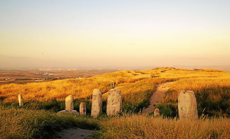
Standing Stones (Mazzeboth): The high place at Gezer features ten monolithic stone steles, the tallest standing three meters high. These stones are arranged in a north-south orientation, and in front of one of the steles is a large stone basin thought to have been used for libations during cultic ceremonies. The precise purpose of the stones remains debated among scholars. The prevailing view is that they formed part of a Canaanite sacred precinct, possibly marking a treaty or covenant site where representatives of different tribal groups assembled. The row of standing stones dates to the Middle Bronze Age, making it one of the oldest preserved sacred installations in the country.
Water System: Gezer’s water system is a remarkable feat of ancient engineering. It includes a deep rock-cut shaft and tunnel system that provided a reliable water source to the city’s inhabitants. The shaft descends about 25 meters, connecting to a horizontal tunnel that leads to a subterranean water source. This system highlights the ingenuity of the city’s engineers in ensuring a sustainable water supply, particularly during sieges. The entrance to the shaft is visible on the tel, though descent into the tunnel is not currently open to the public.
City Walls: The fortifications at Tel Gezer are extensive, reflecting the city’s strategic importance. During the Middle Bronze Age, a massive wall and glacis were constructed, measuring about 7.5 meters high. In the Late Bronze Age, a new outer wall was built, 1,100 meters long and 4 meters thick. These walls are among the few known fortifications from this period in the region, indicating Gezer’s significant political status under Egyptian rule. Sections of both wall systems are visible from the walking path, allowing visitors to see the physical scale of the city at its height.
Canaanite High Place: The high place is another significant feature at Gezer. This cultic area includes altars and stone steles used for religious practices. Excavations have revealed that this site was actively used during the Middle Bronze Age, providing insights into Canaanite religious life and practice. The proximity of the high place to the city’s main gate suggests it played a public and civic role, not simply a private or priestly one.
Gezer Calendar Replica (לוח גזר): Discovered in 1908 by R.A.S. Macalister, this limestone tablet dates to the 10th century BCE and is one of the oldest known examples of early Hebrew or proto-Canaanite writing. The calendar describes the agricultural year in ancient Israel, listing eight seasonal activities such as planting flax, harvesting barley, and pruning vines. The original is held at the Istanbul Archaeological Museum; a replica is displayed on-site. This artifact provides a direct, human-scale window into the daily life and rural economy of ancient Gezer.
Practical Information
Tel Gezer is an open archaeological site managed by the Israel Nature and Parks Authority. As of 2025, entry to the tel is free of charge; there is no staffed visitor center or ticket booth at the site itself. The site is generally accessible during daylight hours, though there are no fixed opening or closing times enforced on-site. Visitors should bring water, particularly in summer, as there are no refreshments available.
Parking is available in a gravel lot at the base of the tel, off Road 3 near Kibbutz Gezer. The path up the tel is a moderate walk of about 10 minutes on an unpaved track.
Additional Information
Tel Gezer – Biblical Archeology
Discerning History
New Evidence for the 10th Century BCE at Tel Gezer
End of the 4th millennium BCE:
- First settlement is established at Tel Gezer, utilizing large caves cut into the rock for dwellings.
- Stratum XXVI: Beersheban Chalcolithic period settlement.
3rd Millennium BCE (Early Bronze Age)
- Beginning: An unfortified settlement covers the tell.
- Middle of the 3rd millennium BCE: Settlement destroyed by fire and abandoned for centuries.
First Half of the 2nd Millennium BCE
- Gezer becomes a major fortified Canaanite city-state.
- Massive city walls, stone towers, glacis, and large gate constructed.
- Unique cultic site with ten monolithic standing stones (massebot) and large basin established.
- Large Canaanite water system built.
Second Half of the 2nd Millennium BCE (Late Bronze Age)
- New city wall, 4 meters thick, constructed outside earlier fortifications.
Thutmosid Period (1479–1425 BCE)
- City destroyed by Pharaoh Thutmose III.
- Oldest historical reference to Gezer found at Thutmose III’s Karnak temple.
Amarna Period (14th Century BCE)
- Gezer mentioned in Amarna letters, kings swear loyalty to Egyptian pharaoh.
- Palace constructed on acropolis; remains of possible Egyptian governor’s residence discovered.
Ramesside Period (Late Reign of Ramesses II – 13th Century BCE)
- Climate turns drier and colder, causing turmoil.
- Cities in Canaan rebel after death of Ramesses II. Pharaoh Merneptah captures Gezer; extensive fiery destruction occurs.
- Skeletal remains from Egyptian invasion discovered.
Iron Age (1200–586 BCE)
- 12th–11th centuries BCE: Large building (possibly granary) and olive presses built; mixed population evident.
10th Century BCE (Time of Solomon)
- Urban development and fortifications.
- Egyptian pharaoh (possibly Siamun) destroys Gezer, gifting it to King Solomon as dowry.
- Solomon rebuilds Gezer, constructing a six-chambered city gate.
- Creation of the Gezer Calendar.
- City destroyed again, possibly by Shoshenq I.
9th and 8th Centuries BCE (Iron IIB)
- Population approximately 3,000.
734–732 BCE (Neo-Assyrian Period)
- Gezer besieged and destroyed by Tiglath-Pileser III.
- Major fiery destruction and pillared buildings destroyed.
Late 3rd Century BCE–142 BCE (Hellenistic Period)
- Occupation indicated by artifacts such as amphora handles and coins.
- City known as Gazara under Hasmonean rule.
- Simon Thassi captures and fortifies Gazara, integrating it into Hasmonean kingdom.
Roman and Byzantine Periods
- Sparse population; bathhouses, ritual baths, and rock tombs identified.
- Gradual abandonment during late Roman–early Byzantine period.
1177 CE (Crusader Period)
- Battle of Montgisard occurs near Gezer; Crusaders defeat Saladin.
1871
- Charles Clermont-Ganneau identifies site as ancient Gezer.
1874–1881
- Clermont-Ganneau discovers four bilingual boundary stones.
2023
- Revised interpretations correlating destruction layers with biblical and historical events published. Lindelle C. Webster’s excavation team concludes that correlation of Stratum IX (11th century BCE) with Solomon and Siamun is improbable, and correlates Stratum 8 destruction (mid-10th century BCE) with Shoshenq I’s reign.
What is Tel Gezer and why is it significant?
Tel Gezer is an ancient mound in Israel’s Shephelah region that preserves more than five thousand years of settlement history, from Chalcolithic cave dwellers through Canaanite city-state builders, Egyptian-controlled administrators, Israelite kings, Hellenistic rulers, and Roman-era residents. Its significance rests on several pillars: it appears repeatedly in the Hebrew Bible, its six-chambered gate is one of three linked to King Solomon across the country, and it produced the Gezer Calendar, one of the oldest inscriptions in early Hebrew script ever found.
How long does it take to visit Tel Gezer?
A self-guided walk covering all the major features, including Solomon’s Gate, the standing stones, the water system, and the city walls, takes approximately one to two hours at a relaxed pace. Adding a licensed guide extends the visit meaningfully, typically to two to three hours, and provides context that the on-site panels alone cannot fully supply.
What is the Gezer Calendar and where can I see it?
The Gezer Calendar is a small limestone tablet discovered by R.A.S. Macalister in 1908 during the earliest systematic excavations at the site. Dating to the 10th century BCE, it lists eight agricultural seasons in sequence, from olive harvest through grain planting, and is considered one of the oldest surviving examples of early Hebrew or proto-Canaanite writing. The original is held at the Istanbul Archaeological Museum in Turkey; a replica is displayed at the tel itself.
What is Solomon’s Gate at Tel Gezer?
Solomon’s Gate is a six-chambered Iron Age city gate constructed at Gezer during the 10th century BCE, attributed to building projects carried out under King Solomon after an Egyptian pharaoh gifted the city to Solomon as part of his daughter’s dowry. The gate follows an identical plan to gates uncovered at Hazor and Megiddo, a design consistency that has led most scholars to assign all three to the same royal construction program. Its chambers, towers, and drainage channel are still largely intact and form the most visually dramatic structure on the tel.
Are the standing stones at Tel Gezer the oldest in Israel?
The ten standing stones at Gezer, dating to the Middle Bronze Age (roughly 1800 to 1550 BCE), are among the best preserved Canaanite sacred stone installations in the country and among the oldest in situ ritual monuments still visible at an open site. Similar mazzeboth have been found at other Bronze Age sites, but the Gezer row is exceptional for its completeness, with all ten stones still upright or recoverable, and for the accompanying stone basin that confirms a cultic function.
Nearby Sites
- Emmaus Nicopolis: An ancient city with ruins from the Roman and Byzantine periods.
- Latrun Monastery: A Trappist monastery known for its peaceful surroundings and beautiful vineyards.
- Neot Kedumim: A biblical landscape reserve that recreates the agricultural and ecological environment of ancient Israel.
- Tel Lachish – One of the most famous Tels in Israel mentioned extensively in the Bible.
Keep reading
Part of our Shephelah & Central Israel Guide →