The Cardo Maximus was the main north-south street in Roman and Byzantine Jerusalem, serving as the city's central thoroughfare. Built initially in the 2nd century CE and expanded in the 6th century, this colonnaded avenue connected major city gates and remains partially preserved in the Jewish Quarter today.
The Cardo Maximus is Jerusalem’s ancient north-south main street, built in the 2nd century CE and expanded in the 6th century. Today, a preserved 600-meter stretch runs through the Jewish Quarter of the Old City, where you can stand on original Roman paving stones that lie 2.5 meters below the modern sidewalk. The Cardo street runs from the Damascus Gate in the north toward the Zion Gate in the south.
What is the Cardo in Jerusalem?
The word cardo comes from Latin, meaning “hinge” or “axis.” In Roman urban planning, the cardo maximus was the spine of every major city, running north to south, with all other streets organized around it. Jerusalem’s Cardo Maximus ran approximately 1.2 kilometers from Damascus Gate in the north toward Zion Gate in the south, cutting through what is now the Jewish Quarter of the Old City.
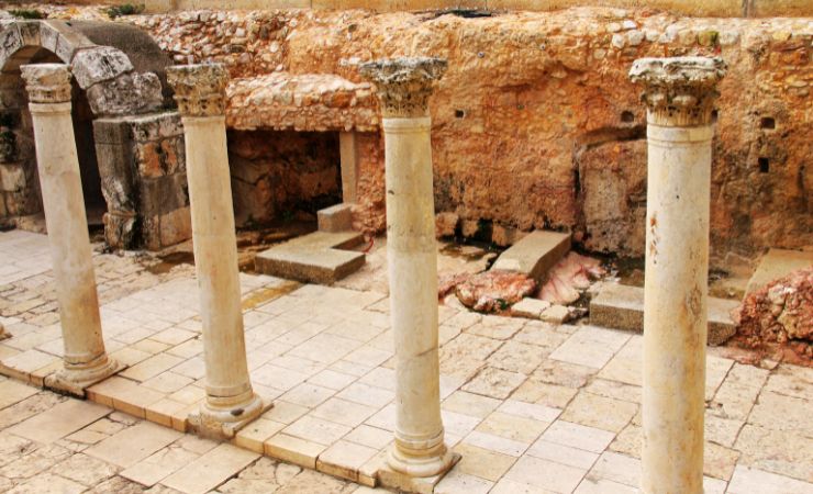
The street was 22 meters (73 feet) wide at its full extent: a 12-meter central roadway flanked by two covered colonnades, their limestone columns spaced precisely 5.77 meters apart. Shops and workshops lined those colonnades, making the Cardo both a civic artery and the city’s primary commercial corridor.
The street underwent significant expansion during the Byzantine period, particularly under Emperor Justinian I (527-565 CE). As archaeological evidence from recent excavations confirms, Justinian extended the Cardo southward to connect the Church of the Holy Sepulchre with his monumental Nea Church near today’s Jewish Quarter.
The Building of the Cardo
The Cardo Maximus in Jerusalem originated after the Bar Kokhba Revolt (132 to 135 CE), when Emperor Hadrian razed the city and rebuilt it as a Roman colony called Aelia Capitolina. Hadrian’s planners imposed a classical grid with two main thoroughfares: the north-south Cardo Maximus and the east-west Decumanus Maximus, intersecting near the Muristan area, which became the city’s central forum.
Emperor Justinian I (527 to 565 CE) later extended the Cardo southward, linking the Church of the Holy Sepulchre to his ambitious new Nea Church. Archaeological excavations confirmed that this Byzantine southern extension was built directly on bedrock, with no Roman construction beneath it, meaning Justinian’s builders started from scratch rather than simply widening an existing road.
The Excavation of the Cardo Maximus
Archaeologist Nahman Avigad conducted the most significant excavations of the Cardo Maximus between 1970 and 1981, focusing on a 600-foot stretch of the southern section within the Jewish Quarter. His team uncovered approximately 60 Byzantine architectural elements, including limestone column bases, fluted columns, and elaborately carved Corinthian capitals. The discovery that many column bases remained in their original positions while other architectural features had been reused in later Crusader and medieval structures provided crucial evidence for the street’s continuous occupation and adaptation over centuries.
A pivotal finding emerged when excavators discovered that this Byzantine section of the Cardo Maximus was constructed directly on bedrock, with no underlying Roman construction. This evidence, combined with pottery analysis and architectural studies, strongly suggests that Emperor Justinian ordered the southern extension’s construction as part of his massive building campaign in Jerusalem. The excavations also revealed the remains of the Nea Church, Justinian’s ambitious project to rival the Church of the Holy Sepulchre. One original column from the Nea still stands adjacent to King David’s Tomb and the Room of the Last Supper, providing a tangible connection between the Byzantine street and its monumental destinations.
What Can Be Seen at the Cardo Today?
Open-Air Excavated Section — The reconstructed open-air stretch runs approximately 150 meters through the Jewish Quarter, sitting 2.5 meters below modern street level. Walking along the original limestone paving stones, you can feel the slight unevenness worn into them by 1,500 years of foot traffic before the street was buried. The full 22-meter width, divided into the central roadway and two colonnaded walkways, is visible here more clearly than anywhere else along the route.
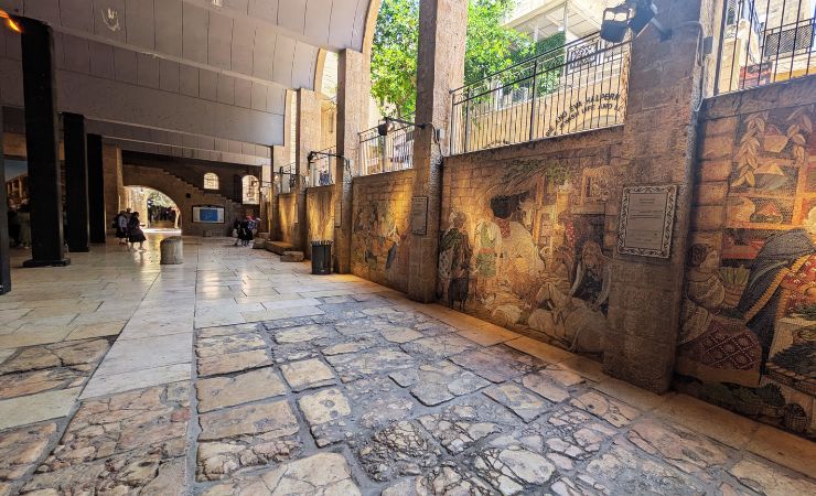
The Covered Shopping Arcade — Modern restoration turned a portion of the ancient Cardo into a covered arcade where contemporary shops occupy spaces built inside Crusader-era vaults. Those medieval vaults were themselves built atop Byzantine foundations, so a single afternoon of browsing souvenirs takes you through roughly 1,500 years of Jerusalem’s commercial history without leaving the building.
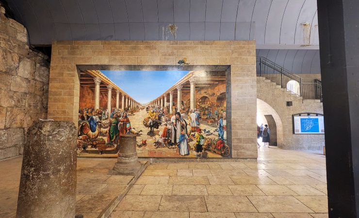
The Byzantine Wall Mural — A large, colorful mural painted along the excavated section recreates the Cardo’s appearance during the Byzantine period, showing merchants, pilgrims, and architectural details drawn from archaeological findings. Artist Dan Carmel embedded three specific figures in the scene: former Jerusalem mayor Teddy Kollek, archaeologist Nahman Avigad, and a self-portrait. He also placed a modern-dressed boy in the lower right corner, creating a deliberate time-traveler effect that makes the ancient street feel suddenly close.
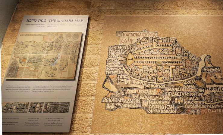
The Madaba Map Reproduction – The Cardo displays a faithful reproduction of the Madaba Map, a 6th-century mosaic floor discovered in a Jordanian church in 1896. The original Byzantine map depicts Jerusalem from an aerial western perspective, showing the Cardo Maximus as a straight, colonnade-lined avenue running from Damascus Gate to the Zion Gate area. Its accuracy is remarkable: red tile roofs, column spacing, and wooden structural elements that excavations later confirmed. Archaeologists used the map as a guide for locating the Cardo’s remains, a rare case of medieval religious art serving as a precise archaeological tool.
Sites Along the Cardo in Jerusalem
- Damascus Gate: The northern terminus of the Cardo Maximus, this imposing Ottoman-era gate built on Roman and Crusader foundations marks the main entrance from the north. Archaeological excavations beneath the current structure have revealed remains of Hadrian’s triple-arched Roman gate.
- Station 7 of the Via Dolorosa: This traditional stopping point along the Christian pilgrimage route marks where Jesus allegedly fell for the second time while carrying the cross. The station lies close to the ancient Cardo’s path through the Old City.
- Junction with Decumanus Maximus (Muristan Area): The intersection of Jerusalem’s two main Roman streets created the city’s central forum, later occupied by the Muristan complex. This area served as the commercial and administrative center of Aelia Capitolina, housing temples, basilicas, and market facilities.
- Ecce Homo Arch and “Lithostratos” (Eastern Forum/Struthion Pool Pavement): This triple-arched Roman gateway near the Struthion Pool marked the entrance to Hadrian’s secondary eastern forum. The well-preserved stone pavement beneath the Convent of the Sisters of Zion provides insight into Roman paving techniques and urban design.
- Crusader Period Markets: Medieval Crusaders constructed three covered markets (the Goldsmith’s Street, Spice Street, and Butcher’s Street) directly over the Byzantine Cardo’s foundations between 1099-1187 CE, adapting the ancient street grid for their commercial needs.
- Nea Church (Byzantine): The substantial remains of Justinian’s 6th-century basilica once stood as Jerusalem’s largest church, connected to the Holy Sepulchre via the Cardo’s southern extension. Modern excavations have revealed the church’s impressive apse and foundation walls.
- Zion Gate: The southern terminus of the extended Byzantine Cardo, this gate provided access to Mount Zion and the early Christian communities that developed outside the Roman city walls.
Practical Infomation
The open-air excavated section of the Cardo Maximus is free to enter and accessible 24 hours a day. The covered shopping arcade keeps standard business hours. The site is reached through the Jewish Quarter of Jerusalem’s Old City; no advance booking is required.
Additional Information
Roman Period and the Founding of Aelia Capitolina
- Pre-135 CE: Emperor Hadrian makes the decision to establish a Roman city in Jerusalem with a pagan temple on the Temple Mount, leading to the construction of Aelia Capitolina.
- 130 CE: Emperor Hadrian visits Jerusalem during his imperial tour.
- 132-135 CE: The Bar Kokhba Revolt, a second Jewish uprising, occurs in Judea, with devastating effects on the local Jewish population.
- 135 CE: The Bar Kokhba Revolt ends. The Roman city of Aelia Capitolina is founded on the ruins of Jerusalem by Emperor Hadrian. The city is intended as a Roman colony, a traditional settlement for veterans, and an armed outpost of Rome.
- After 135 CE (Founding of Aelia Capitolina): Roman administration takes over the city’s lands. A significant portion of the population consists of Roman army veterans and settlers from the western empire. A temple dedicated to Venus is built in the Muristan area, possibly near or next to a temple of Jupiter. Two main streets, the Cardo and Decumanus, are laid out as part of the typical Roman grid plan. The Cardo Maximus (main north-south street) runs from Damascus Gate to Zion Gate, and a second eastern Cardo (Cardo Orientalis) runs from Damascus Gate to Dung Gate (later extending to Siloam).
Byzantine Period
- 324 CE – 337 CE (Constantine’s Reign): Emperor Constantine, who became Emperor of the Roman Empire in 324 CE, builds in Jerusalem, including the Church of the Holy Sepulchre. There is a debate about whether he extended the Cardo.
- 527 CE – 565 CE (Justinian’s Reign): Emperor Justinian builds a large church, “Nea Church,” in the area of today’s “Batey Mahaseh.” The Byzantine Cardo in the Jewish Quarter is dated to his period (6th century CE), connecting the Church of the Holy Sepulchre with the Nea Church. This Cardo is confirmed by Byzantine pottery and Corinthian capitals found in excavations, and its construction follows the Byzantine foot (32 cm) rather than the Roman foot (29.6 cm). Important religious processions occur along this axis.
Later Periods
- 614 CE – 629 CE: Persian control of Jerusalem lasts until 629 CE.
- Crusader Period: The Cardo, as Jerusalem’s main longitudinal street, continues to serve this function. It branches into three Crusader market streets (Goldsmiths Street, Spices Street, Butchers Street) near the Church of the Holy Sepulchre. This market, called “Goods Sale Market,” is built on the Cardo’s alignment. Today, the names of the two streets on either side are Jewish Street and Chabad Street.
What is the Cardo in Jerusalem?
The Cardo in Jerusalem is the ancient Roman and Byzantine main street of the city, running north to south through what is now the Jewish Quarter of the Old City. Built in the 2nd century CE and expanded in the 6th century, it was 22 meters wide and lined with colonnaded shops.
What is the oldest street in Jerusalem?
The Cardo Maximus is widely considered the oldest identifiable street in Jerusalem. Its earliest Roman phase dates to around 135 CE, when Emperor Hadrian rebuilt the city as Aelia Capitolina after the Bar Kokhba Revolt. Original paving stones from the Byzantine period are still visible 2.5 meters below today’s street level.
What is the difference between the Roman and Byzantine Cardo Maximus?
The Roman Cardo was built around 135 CE as part of Hadrian’s Aelia Capitolina and ran from Damascus Gate southward approximately 1.2 kilometers. The Byzantine extension, constructed under Emperor Justinian in the 6th century, extended the street further south to connect the Church of the Holy Sepulchre with the new Nea Church, using different architectural measurements and more elaborate colonnaded design.
Can you walk on the original Cardo Maximus stones?
Yes, visitors can walk along sections of the original Byzantine paving stones in the excavated open-air area of the Jewish Quarter. The ancient street surface lies about 2.5 meters below the current street level and features the original limestone paving blocks installed during the 6th century.
Why is the Jerusalem Cardo Maximus significant for Christianity?
The Byzantine-era Cardo Maximus served as a ceremonial processional route connecting Christianity’s two most important churches in Jerusalem: the Church of the Holy Sepulchre and Justinian’s Nea Church. Christian pilgrims used this colonnaded avenue for religious processions, making it a central axis of Byzantine Christian Jerusalem.
What happened to the Cardo during the Crusader period?
Crusader builders constructed three parallel covered markets directly over the Byzantine Cardo’s foundations between 1099-1187 CE. These markets (Goldsmith’s Street, Spice Street, and Butcher’s Street) adapted the ancient street’s alignment for medieval commercial use, with many of their stone vaults still visible today in the modern shopping arcade.
What architectural elements from the original Cardo can still be seen?
Visitors can observe original limestone column bases still in their ancient positions, reconstructed columns, carved Corinthian capitals, and sections of the original paving stones. The excavations also revealed parts of the ancient drainage system and shop foundations that lined the colonnaded walkways.
Keep reading
Part of our Jerusalem Travel Guide →